Showing posts with label Potholes. Show all posts

Wednesday, July 23, 2008

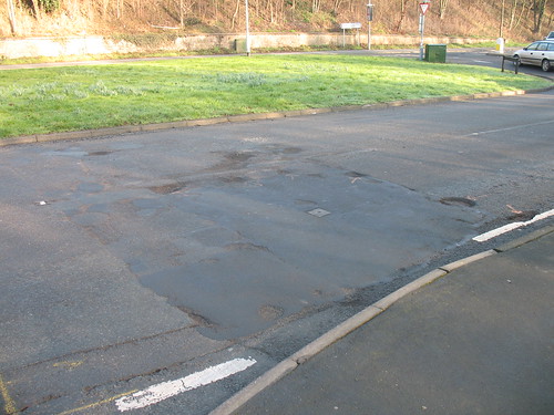
Stour Bridge hole

So this hole was first dug on the 17th of November it was patched on the 22nd and sunk again the following day. I have a record of a report I sent on the 11th December and the hole was redone on the 14th.

I note in March that it's become a sharp-edged depression. This is then seriously topped up to make a bump and now it's back down into a depression again.

Another report via the whub - entered my email address and password and got rejected before recalling that I used the other log in page that asks for user name and password [sigh]

To recap:

Dug on the 17th November
Patched on the 22nd November
Patched on the 14th December
Patched around March
Now requires filling in again.

Perhaps it's all a scheme to keep the repair crew off the dole?

Tuesday, April 29, 2008

Proper roadworks, but more work needs to be done

Some congratulation needed, Ringway on behalf of the council are resurfacing great slabs of road on Areley Common.

They've headed down towards Dunley Road and so far finished at the area below (shown prior to work) before heading up Hermitage Way.
Now providing the work holds (as the previous work clearly didn't) this is indeed much better then all the patch jobs we've been getting and it's possible that once the pavement work on the bridge is done it might extend into town and beyond. Hopefully getting to the Dunley Road entrance and exit on Areley Common too (top right of photo).

So to that end here's the fun bits; ignoring ones I've already photographed. First off what the hell has happened to the cover close to the exit on Areley Lane? The square cut around it seems to have completely lost its surface, it's like switching from tarmac to gravel and back over a tiny stretch.

Next up the bridge. I've already mentioned and photographed the recessed covers, but let's talk about the dip. Drive out of town and just as the brickwork wall switches to stone - fump, down you lurch to the left. This is the new surface and it's just not acceptable because it has pothole precursor written all over it. Who the hell went over and approved this work?

York Street is still breaking up and starting to form pot-strips just as I predicted; in the same vein the Stour Bridge is beginning to have the same problem with the tearing concentrated more on the town approach (oh and yes the inspection cut is still depressed though seems to be stable).

While there, the exit past OGL that got a bit of patching done while the water board were there (hell they're still there) should have been slabbed at the same time.

Finally Vale Road is still unpleasant. The depressed square in the third lane has been there so long I'm autopiloting around it. The new nastiness is on the way out of High Street; staying in lane 1 is lurchy thanks to a pot-strip and tyre-shreddingly noisy if you try to switch lanes. Of course the joy of any work at this point means an official diversion up to Bewdley Road via Lickhill - not fun and not one any of the locals will take instead vanishing down car-choked Vernon Road.

I could continue with Wilden Lane, etc. but we all know how bad it is along there.

Okay enough about the potholes and on to the pavement work. I've already voiced concerns over what's going to happen when the utility companies dig up this nice fancy paving so I'll pass on that. Instead it's been pointed out to me that a) the work applies to the official pavement and only the official pavement and b) it stops at a clear demarcation line at the top corners.

Now "a" is understandable the owners of the premises are responsible for the point at which the building meets the pavement, likewise there's the Basin Link to consider; but I've been told it causes the work to look half-done. "b" on the other hand is a bit stranger, why stop so short? Rumour has it that instead of re-paving they're going to be painting the pavements. Now this might have some connection to the redevelopment plan and talks of decoration on the Basin Link, but to be blunt the answer is - I don't know. When I get some daylight on the weekend I'll have a closer shuftie.

Tuesday, March 18, 2008

Stourport road update

The two big holes that got missed out of the repair round last time have been filled (although new ones have sprung up in the opposite lane to the ones they previously fixed), as has one on the Bridge Street/High Street island, and the left hand lane leading from High Street to Vale Road.

I'll check on the one in lane 1 of Vale Road itself at some point, the square in lane 3 Vale Road next to the caravan sales is still depressed enough to jolt you if you go over it at any speed above 20mph unless you cut to the left or right. The multiple-repaired hole on the Stour bridge is so far holding steady at a slight sharp edged depression, but the lane opposite it leading into Stourport is starting to break up, as is the bottom half of the road in York Street. The exit onto Worcester Road is in the same state it's been for a while i.e. horrendous, but I'll acknowledge it's been difficult with the building going on around it.

With that in mind the parts they've dug up for the building work are not level with the rest of the road so we have a sharp edged depression running along both lanes. Further along coming into Stourport in Wychaven's territory I note a foot long crack leading from one of the drains.

Mitton Street's a little odd at the moment with the left hand lane coned off just before Stour Lane, to force you into the other lane so you avoid the hidden set of roadworks around the corner, people being people here of course they drive around the cones and get back into lane before grinding to a halt. Don't know what they're doing but someone was also moving barricades up near the top too.

Oh and the river's up enough to overflow the Engine Basin, though that's hardly news as that seems to be happening at least once a week now.

Tuesday, February 19, 2008

Foggy Bottom

Really didn't want to get up this morning, stuck a toe out and went "Bruuuh!"

I could just about see the houses across the street this morning. Going over the bridge was a sea of white I couldn't even see the town and yet despite this there were still vehicles driving along with no lights on; heck even I turned my lights from low to full a couple of times.

Vale Road was blocked amusingly by the first lane rather then the third lane which was relatively clear that is if you could get to it.

In other news, as mentioned in the comments of my previous entry, Lickhill Road is still closed they'd just moved the signs about so you couldn't see them as clearly. Here's how they were originally.

Lickhill Road Closed

Now the Swan Garage sign has moved next to the Diversion Sign, the Lickhill Road Closed sign has moved back to replace it and a Roadworks Left sign put a couple of yards in front of it.

The works in York Street that had taken over two lanes have decamped over to the right-hand lane, in a shock they've updated the sign on the entrance from Lion Hill telling you this.

They have indeed filled the potholes as shown originally here they don't seem to have done any others though not even the nearby ones they drove over to get there.

Monday, February 18, 2008

Stourport town and road update.

Just a quick update on the state of the town

The old indoor market is now fully boarded up so I'm expecting renovations from M & Co to start soon.

The Road Closed signs on Lickhill Road from High Street were gone though the roadworks were still present, so may have been a glitch at their end.

The Severn Trent works in York Street appears to be expanding. The main set are still in place on the left-hand lane apparently next to the work they did last year, the parking bays behind it are still reserved by cones, but now they've dug up something opposite those bays and cordoned it off. So now, paying attention to the road sign telling you the left-hand lane is blocked, you stay in the right-hand lane (as you should anyway) then have to jink to the left between the new works and the parked vehicles before switching back to the right to squeeze past the original works. Someone should point out that longer vehicles don't exactly have this flexibility of motion.

And finally I watched a Worcestershire County Council van start to patch some holes. From the small part I saw this consisted of a man, a spade, and a bucket tipping hot-fill into the holes whenever the traffic allowed him to step out into the road. They may have set up a coned section later, but I was not present to observe this.

Friday, February 15, 2008

The Shuttle hits a double

Quite astonishing that our local paper has managed to shoot out two stories that I've been talking about for ages, no wait they're actually letters from readers they've just published.

The first is complaining about the potholes in Kidderminster oh no wait Stourport does get a brief mention too, though I've no idea why it's not as if we have any potholes here.

My favourite quote is from Mr Shrimpton who blames the fast deterioration on rains and snap freezes… no I think the blame can be laid on simple shovelling in a bit of fill and slapping some tarmac on the top before calling it a day. Okay a little unfair the weather does have some influence, but when some of these holes aren't even sealed then what do you expect?

The second letter highlights the problems with Gilgal, but really has some bearing on the entire road layout of Stourport. I've commented there, but I'll reiterate and reorder my thoughts here.

As has been mentioned several times before Stourport is one big one-way system that feeds back into itself; this means a block at one point can screw-up the entire system. Sadly the roads were simply not designed to take the volumes of traffic they normally see and hold-ups become a way of life for those of us using them.


View Larger Map

Let's start with Bridge Street. This should be trouble-free it's just a standard two-lane bi-directional flow, except now due to the parking bays and the position of the lane divider those heading up into town must give-way to those coming from town. While this problem, in theory, existed prior to the painting of the parking bays it has now been made explicit; combine that with a pedestrian crossing with a mind-numbing long wait period and traffic will start to slow down and build up.

It gets little better when you hit the junction at the top, which was turned into a mini-island quite some time ago. Due to this traffic from York Street has right-of way over traffic from Bridge Street when crossing over to New Street. As this option is barely made noticeable such traffic treats this junction as a simple left-turn and fails to indicate; the Bridge Street traffic stutters at this point.

New Street is again a simple two-lane bi-directional set-up with the added burden of a set of traffic bays in the left-hand lane approaching the island. Thus anyone turning into here from that side runs the possibility of meeting another vehicle driving up the middle of the road. Like those in Bridge Street drivers in New Street are presented with the same problem of traffic from York Street not indicating, thus they may think they can exit because the Bridge Street traffic will be halted by the crossing York Street vehicle only to find it isn't and hasn't.

High Street a two-lane one-way system, except it's not two-lanes; or it might be? The lane divider peters out past the island and only re-starts at the other end of the street. No signs indicate the lack of road markings, thus strictly speaking this is one big merger lane with the priority going to whoever gets in first. The traffic wardens have done a good job in keeping the right-hand 'lane' clear, which was the main bone of contention, yet the majority of traffic sticks to the middle of the road just in case (besides as mentioned it is really one lane). Problems can arise with the indented bus-stop that doesn't allow the longer buses to fully pull into it, or allow more then one short bus to use it at the same time. These buses then 'park' outside the stop thus blocking the left-hand 'lane'.

Into Vale Road a three-lane one-way system. Heading from High Street you can travel straight into the first lane, the other feed road (Mitton Street) has priority over the other two lanes. Because of this it is impossible to know whether a vehicle entering Vale Road from Mitton Street will move into lane 2 or lane 3 (they're not changing lanes so no requirement to indicate) for any vehicle trying to change from lane 1 into lane 3 this makes life difficult with a large flow of traffic.

Just for fun add in two petrol stations off lane 1, oh and a non-indented bus stop before all that.

Onto Gilgal, which is a two-lane one-way system. Zoom in on the above map in satellite mode without labels and you'll see the problem. Traffic flowing from the Minster Road traffic lights has an easy ride of this, a simple downhill curve to the left, it's also exceedingly easy to switch from the left-hand lane to the right-hand lane as it's on the same curve. Compare to the curve if you head from Vale Road and it's not as simple - a tight corner on the brow of a hill and an easier corner to take if you move directly to the left-hand lane.

So one feed that allows easy access to both lanes and another that's easier if you pick the lane you're don't have priority for - predictions anyone?

Moving downhill it's also noticeable that this road isn't straight, it is also quite narrow and gets narrower, then splits into two directions. Now note that the left-hand lane goes round a 90° degree corner over a narrow bridge before screeching to a halt at another poorly designed island. If I now mention that the majority of morning traffic is heading in this direction predict the actions of those heading from Vale Road to use this lane.

Onto Mitton Street, which is another two-lane one-way system that shares many of its flaws with Gilgal. Traffic feeding in from Worcester Road into the left-hand lane faces another tight corner while those feeding from Gilgal have a simple curve. The road is again narrow with yet another tight corner in the middle of it. Add in that this road has businesses on it and thus parked vehicles and you may wonder how this can function as a merger system at all.

Into Lion Hill and here we do have a two-lane one-way system that should work. Both feeds from Mitton Street and High Street have the same 90° corner, the road is reasonably straight and runs for a moderate distance; note I said should.

Gradient plays its part - traffic from Mitton Street is heading uphill, High Street downhill. The likelihood of finding a parked car in the left-hand lane is much higher then for the right-hand lane and no you can't see until you've turned the corner and committed yourself. Like Gilgal the majority of traffic wants to use the same lane in this case the right-hand one and queues build up down York Street and feed into this lane.

York Street, like High Street a possible two-lane one-way system though in this case the missing lane divider is due to simply not re-painting it, flecks still exist. This should be the easiest road in the town, the only other feeder is from the low-volume Lichfield Street which can't use its priority in the left-hand lane due to the recent moving of a set of parking bays directly in its path; nevertheless it still has that priority and thus traffic flowing from Lion Hill should remain in the right-hand 'lane'.

The road is wide enough to accommodate a set of parking bays down its left-hand side, unfortunately it has vehicles legally (semi-legally) parking down the right-hand side too. So again like High Street all traffic heads down the middle of the road until it reaches the island. Here the left-hand lane gets blocked by the bus stop and the right-hand lane gets blocked because of the vehicles parking opposite the bus stop.

Those vehicles who've managed to remain in the right-hand lane can now turn sharply into the right-hand 'lane' of High Street. Those in the left-hand lane cannot see what the traffic coming up Bridge Street is doing and thus has to assume then whenever a vehicle is trying to turn right out of New Street has right-of-way over them before they can make a sharp turn left. Those heading into New Street will find that most local Bridge Street traffic will ignore the fact they aren't signalling to turn left, because no-body does.

I won't even begin on the fun to be had when you get a longer vehicle trying to turn in either direction out of York Street.

So that's Stourport a small mix of bad driving on a road system not designed for the load it's carrying. Come and visit why don't you, just um don't drive here.

Monday, February 11, 2008

A photo filled weekend

A relatively busy weekend I spent most of Saturday morning snapping pictures of the pot-holes in Stourport. To be honest I don't know why I bother, I could just repeat the same ones I've already taken as the majority are all in exactly the same places. The patches seem to last around a month (or less) before they start to sink or break up taking more of the surrounding area with them and we're left with an even bigger hole.

[Update pictures start here]

Same old, same old; Dunley Road opposite Harold Davies Drive, Areley Common turn and as an added bonus on Areley Common at the Hermitage Way turn though those have all been thoughtfully pointed out with orange spray-painted arrows. The road edge for the drain on the corner of Lion Hill and York Street is really starting to fail a real pain for those of us who at least attempt to pretend York Street is two lanes. Oh and we have a new one on the Bridge Street island, again only really noticeable for those of us who drive around the white circle rather then over it like everyone else.

The covers on the newly resurfaced Bridge Street are still recessed so I'm expecting those to start to fall in with repeated use as we've already got one large cover clonk-clonking as it's driven over. Again am I stupid or something - "Hey the best place to put these covers is just off-centre of the lane rather then in the centre of the lane or even the centre of the road"

Speaking of which I didn't manage to get a shot of the collapsing cover in the middle of the road close to Cook's on the Worcester Road. But, you say, if it's in the middle of the road how is it collapsing? Because it's next to a row of houses that often have cars parked in the road so it takes a hit every time they're overtaken.

Heh and speaking of that type of thing the pavement markings next to the bays in Bridge Street finally caught my attention (I'm trying to decipher what they mean). These are the ones where instead of veering the lane divider out to allow both streams to pass it was 'decided' to keep the lane marker where it was so everyone coming up Bridge Street has to overtake the parking bays. Understandable if the road was narrow except...

Oh and we had a traffic warden out doing his job in Hight Street. I took a snap and he walked up to ask what I was doing -

"Just taking a photo; you know you doing your job, hard at work"
"I'm sorry that's a breach of my Human Rights"
"Ookay there we go deleted"

I could have argued that he was in a public place and therefore could hardly be expecting privacy, I could have pointed to the numerous CCTV cameras around, but I'm fundamentally a nice guy and if someone objects to their photo being taken I can relate. My only annoyance is that in my criss-crossing through town he seemed to make a special note of me as if I'd try to get a sneaky shot of him.

Popped into the Sweet Jar for my fix and a chat. Again the major plug all the sweets you remember as a kid and Sugar-Free ones too. So for me my Jelly Beans, Mint Imperials, Rum Truffles, and a new addition Mint Crumbles (very nice too). Anyway the owner mentioned the dings he had to take out of the skirting of his new mini-van going over speed-bumps, the leaking suspension something (hey for me car equals thing with four wheel) from the pot-holes and the £300+ bill for the broken spring going up to Shrawley after he missed avoiding a Dr Foster style hole. I mentioned my father having to have something knocked out when he went through a water filled pot-hole. I'd also like to blame the number of times my clutch cable's gone on them too, but I'd don't think I legitimately can.

Missed seeing my cousin, his wife, and Devil Child on their visit; though apparently he was the worse for wear having dragged himself in from a pub-crawl at 5am and Devil Child spent most of the time asleep. So little to miss.

Sunday was some more shopping in a forlorn quest for Beef Jerky which I couldn't find on Saturday. I swear it was sold everywhere until someone asks me if I can find some for them, ah well.

I then tried out a demo of Drake's Fortune on the PS3 which left me underwhelmed, which I'll blog about later (no doubt before I get to a full review of HalfLife2, it's coming I promise).

Found yet another bug in Killzone (PS2) which led to me restarting a level about 10 times, which gets recorded on my profile.

Blast from the past with Devil May Cry (PS2). Were the camera angles and controls this frustrating when it first came out?

Tried to stay away from Oblivion. Succeeding so far, but may lose the fight when they finally release the expansion disc in Europe.

Oh and I wake up this morning to the breakfast news still going on about what the Archbishop didn't say.

Wednesday, November 21, 2007

Dig up the road and create your own pothole

Amazing they close the Stour bridge for one Saturday evening, dig out a square and already it's turned into a full-blown pothole. Yep all that nasty rain and bit of snow seems to have taken off the obviously insubstantial top coat and then scooped out the inside. Well I could ring up, but hey the Worcestershire Hub has an online pothole reporting service which I've already discussed here.

Sadly it hasn't changed, it's still telling me that only holes 200mm diameter by 40mm are 'worthy' of reporting. It still asks for a detailed description of the hole with an example showing sizes (in cm) while on the previous page warning me not to try and measure it and yes it still uses user fields for status updates. Ah well at least providing personal information isn't mandatory.

The downside is they'll need to shut down that side of the bridge to fix it, of course they wouldn't have to if these utility companies would actually do their jobs properly in the first place.

[Update 22/11 - I've just been told traffic lights have been set-up and they're fixing it now. Genuine applause for doing it after the morning rush]

[Update 22/11 - So what were they doing because fixing it was not one of those things. Inspection team?]

[Update 23/11 - It's been patched and I use the term in the pejorative, it's already slightly concave]

Friday, August 24, 2007

Perhaps why all government IT projects fail.

A variety of threads pulling to one source the previously mentioned letter and an article in the Shuttle; all link to the transport hub of WCC. The hub page itself isn't too bad barring some of the worcester-centric nature of where they're linking to.

Also a little heavy on the bureaucratic form filling - how do you report a problem with traffic lights, click on the lights? Nope that's an application form to put some up. go to the home and you can see clear links to report a problem with street lights; or highways, which includes non-electrical signs; but nothing else.

Anyway on to the report a pothole page. Oo a definition of a pothole.

Potholes or edge failure 200mm diameter x 40 mm deep
For me that's a handspan and thumb deep So what about long gouges can I report them using this form, how about subsidence of existing potholes? In other words can I report pothole precursors so they can be fixed before they actually might cause a problem?

Onto the report form, which seems to take an age to finish loading despite the page appearing fully rendered. Where to start hmm how about the address
https://eshop.whub.org.uk/eshopcp-hub/incident/
Incident_Service.asp?bLoggedIn=True&new=1&QQ=Yes
&IndividualId=1&iIncidentId=0&CustomerType=individual
&UserAccessLevel=OCPLead&PrimaryId=1&svscode=HIGHDEF&
district=malvern
eshop? I'm not buying anything and what's with all those displayed parameters have you not heard of session parameters; oh and I'm not in Malvern nor am I logged in

Purely in the spirit of research I reversed the logic which had the startling effect of apparently altering nothing. I also switched the "Register" address to 0 or 2 which took me to a login timeout page.

The "Login" address which passes on the same parameters, which again appear to do nothing when changed, tells me that the service requires me to log in and provides me with the fields to do so... yes that would be why I'd pressed the log in button; there's nothing like a standardised page to lift the spirits.

Anyway back to the pothole report form, but hey it's not - it's a Defect Report form. So maybe I can report potential problems, oh goody. Hmm the default locality is Worcester City so what's with the passed Malvern parameter?

Section 4
Please do not complete this section - after you submit your report to the Highways Dept this will be used to provide status updates. You will need to login to be able to view these.
...they're using fields you have access to for status details? Oh dear; oh dear oh dear oh dear.